What can I say about our drive to Ouray Colorado. Breath taking and scary at times! I'm so glad I was not the one at the wheel! I was busy taking pictures and telling Charlie to keep his eye on the road! Forget the beauty get us there in one piece! I will let someone else describe it!
Colorado
Most of U.S. 550 in Colorado is two-lane mountainous highway. It is one of only two north–south U.S. Highways in Colorado which runs west of the
Continental Divide The other route is US 491. The route travels north through the
San Juan Mountains.
The
Million Dollar Highway stretches for about 25 miles (40 km) in western Colorado and follows the route of U.S. 550 between
Silverton and
Ouray,
Colorado. It is part of the
San Juan Skyway Scenic Byway. Between Durango and Silverton the Skyway loosely parallels the
Durango and Silverton Narrow Gauge Railroad.
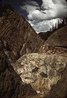
Though the entire stretch has been called the Million Dollar Highway, it is really the twelve miles (19 km) south of Ouray through the
Uncompahgre Gorge to the summit of
Red Mountain Pass which gains the highway its name. This stretch through the gorge is challenging and potentially hazardous to drive; it is characterized by steep cliffs, narrow lanes, and a lack of guardrails; the ascent of Red Mountain Pass is marked with a number of hairpin curves used to gain elevation, and again, narrow lanes for traffic—many cut directly into the sides of mountains. During this ascent, the remains of the
Idarado Mine are visible. Travel north from Silverton to Ouray allows drivers to hug the inside of curves; travel south from Ouray to Silverton perches drivers on the vertiginous outside edge of the highway. Large
RVs travel in both directions, which adds a degree of excitement (or danger) to people in cars.
[3] The road is kept open year-round. Summer temperatures can range from 70-90 degree highs at the ends of the highway to 50-70 degrees in the mountain passes. The snow season starts in October, and snow will often close the road in winter. Chains may be required to drive.
[4]
North of Durango, the highway passes by Trimble Springs, hot springs that have been open for visitors since the late 19th century. The highway runs north along the
Animas River, under the Hermosa Cliffs. It enters the
San Juan National Forest and goes past
Haviland Lake and
Elektra Lake. Drivers pass by
Engineer Mountain and
Twilight Peak before crossing Coal Bank Pass. Next is Molas Pass, which offers a panoramic view of Molas Lake, the Animas River Gorge, and
Snowdon Peak. Northbound travelers then pass through the town of Silverton, elevation 9,320 feet (2841 m), surrounded by 13,000 foot (4000 m) peaks
Sultan Mountain,
Kendall Mountain, and
Storm Peak.
[4]
The highway leaves Silverton and proceeds up Mineral Creek Valley before ascending to Red Mountain Pass. The ruins of the Longfellow Mine are visible along the way. The highway then goes through a series of steep grades and hairpin turns before reaching Lookout Point, which offers a view of the town of Ouray.
[4]

Looking south toward Red Mountain Pass.
Dollar Highway, south of
Ouray.
The origin of the name Million Dollar Highway is disputed. There are several legends, though, including that it cost a million dollars a mile to build in the 1920s, and that its fill dirt contains a million dollars in gold ore.
[1]
U.S. 550 ends at the corner of Townsend Avenue and San Juan Avenue in
Montrose, Colorado at the junction of its parent route
U.S. Highway 50
A view of the Million Dollar Highway pass.
The original portion of the Million Dollar Highway was a
toll road built by
Otto Mears in 1883 to connect
Ouray and
Ironton.
[1] Another toll road was built over
Red Mountain Pass from
Ironton to
Silverton. In the late 1880s
Otto Mears turned to building railroads and built the
Silverton Railroad north from
Silverton over
Red Mountain Pass to reach the lucrative mining districts around
Red Mountain, terminating at Albany just eight miles (13 km) south of
Ouray. The remaining eight miles (13 km) were considered too difficult and steep for a railroad. At one point a
cog railroad was proposed, but it never made it beyond the planning stage.
In the early 1920s, the original
toll road was rebuilt at considerable cost and became the present day US 550. The Million Dollar Highway was completed in 1924.
[4] Today the entire route is part of the
San Juan Skyway Scenic Byway.


.jpg)

Comments